

![]()

![]()
![]()
Summary of our explorations
(1988-99)
Borneo, the third largest island in the world, is a huge region still waiting to be discovered. Its past is just beginning to come into the focus of international interest even if this concerns only one fifth of its territory of 700'000 sq. km.The story of our research began in fact in 1988, when, together with other cavers, Luc-Henri Fage attempted to cross the island from West to East, following the rivers by boats, canoes and bamboo rafts, and walking through the Müller Range separating the Kapuas and the Mahakam rivers. During this one-month trekking, we reached a huge, sofar unknown rock-shelter, Liang Kaung, at the bottom of a limestone outcrop. In the darkest part of the ceiling, we saw many charcoal drawings. These drawings seemed to be of great antiquity. They were the first to be reported in a cave of Kalimantan, the Indonesian part of Borneo. A bibliographical search, carried out at the Librairie Nationale and at the Library of Congress, confirmed that this phenomenon was unknown before.
Four years were then necessary to organize an expedition to explore and study these drawings. By chance I met Jean-Michel Chazine, ethno-archaeologist at the CNRS (Centre National de la Recherche Scientifique), with a large experience of the Pacific area. His broadmindedness, capacity to adapt to difficult situations and a good sense of observation, allowed the 1992 mission to return with a tangible result: in Liang Kaung, we discovered at ground level a place in a remote shelter where fires had been regulary made for a long time. On the charcoal bed, shards of ceramics were discovered. Carbon-14 gave a datation of 3,030 years BP (±160).
This discovery was the starting point of many speleo-archaeological missions, which we carried out together, each one involving speleological and archaeological skills. This investigation allowed us to probe deeply into the history of this island so far largely neglected by archaeologists.
We discovered that almost all the caves of Borneo, independent of their location, had been continously used by man. Up to the present, the shelters are used as bivouacs and the deep caves are visited for their valuable swallows nests. Even recently, Dayak people used the caves for burial purposes. We visited many caverns where impressive stacks of sarcophagi, sculptures, tools or ornaments, jewels, Chinese pottery, etc are piled up. Other caves, as in Liang Kaung, not known to the Dayaks, revealed many shards of paddle pottery and stone tools, dated between 5'000 and 3'500 BP.
But the main surprise was the completely unexpected discovery, in 1994, of the first prehistoric paintings in Borneo. The cave of Gua Mardua revealed to us a panel - 5 meters high - of eight negative handprints (like the oldest forms in Europe, and known throughout the world, except up to then in Borneo), associated with anthropomorphic symbolic motives and figures (flying lizard).
Today, after having just finished our seventh mission in Borneo, having spent a total of nearly 2 years in the jungle, our findings are quite considerable: not less than 12 caves with paintings or indisputable traces of paintings, within an area roughly 100 by 80 km. Limited to the North and to the West by high and steep ridges and crossed by two main rivers, the Karangan and the Bangalon, that area appears to have played an important role in the past, and this not only during the last few millenia, as attested by numerous material cultural remains (i.e. artifacts and funeral items).
Now, six of them, Gua Mardua, Gua Payau, Liang Sara, Gua Masri, Ilas Kenceng and, this years discovery, Gua Tewet, count among the most beautiful ornate caves in SouthEast Asia. Together they contain more than 500 negative handprints (roughly about the same as the negative handprints known in the whole of Europe), but also with the zoomorphic characters (deer tribe, lizard, pig, bovines, worms…) and anthropomorphic characters.
Such as it appears today, this prehistoric rock art presents some similarities with the Aboriginal art of Australia, and the cultural relationship seems obvious, but at the same time, this unknown art developed some unique characteristics in the world. Most astonishing is the superposition of geometrical symbols (herringbones, broken lines, curved, dots…), on the palm and the fingers of the negative hands prints, indicating a body art. Lastly, curved lines, like a family tree, connect some of these hands.
![]()
2000-2001: the project
The surprise created in the scientific community by our most recent discoveries (three major caves, of 1998-99) encourages us to plan to accelerate the work. The cave art of Borneo is not a minor art and its late discovery is due to the difficulties of exploration of this island, still covered by primary forests, with steep and almost inaccessible karstic ranges.The questions
Our discoveries, as surprising as they may appear, leave the field free to all kinds of inquiries: Who were the originators of these paintings? Can one link their paintings to magic or shaman activities? What are their possible cultural links with Papuans or Aboriginals of Australia? What became out of these people? And especially, when did they live in these inhospitable mountains of Borneo?
A systematic prospection
To try to answer these questions, a systematic investigation of the caves is essential. Thus, in Gunung Marang (Marang range), where Ilas Kenceng and Gua Tewet are situated, at least five more caves exist, in which our guides had seen paintings of particular interest. These explorations need time, energy and a good amount of optimism, as well as top health and physical form. Indeed, taking into account the geography of the places, only a prospection on foot, machete in hand, is possible. These explorations are carried out in the company of old Dayak guides who explore the smallest fissures of limestone in search of the valuable swallow nests. Seeing our amazement by what they had perceived only as obscure graffiti, they have learned about the special interest of these paintings to us.
During the survey, we have to document these paintings right away with photographic, topographic, and cinematographic records and copy the paintings onto transparent films. Indeed, our early experience proved to us that excellent logistics in Borneo is the key to success. Far from any village, we have limited autonomy and food. All the exploration should quickly and thoroughly be completed, considering that many years might elapse before a team can return to these ornate caves!
To record paintings in 3D
It is not likely, either, that other teams of archaeologists can come to see the paintings of Borneo, in order to make comparative studies. To share our findings with researchers around the world we would like to document the paintings as faithfully as possible and to show them in their context. We will try to realistically model the cave in three dimensions on a computer. It will then be possible to see the paintings in their surroundings on a interactive display. A researcher, who had never been to Borneo, or in fact any interested person will be able to navigate through the models. They can virtually enter the caves, study the paintings, and admire the unusual karst landscape.
Such a process would combine semi-automated measurements (laser), with pictures (digital video), the whole processed immediately inside the cave on a laptop computer. To my knowledge, this kind of approach has never been used so far, and certainly not under such adverse conditions. This is why we asked for the assistance of Swiss speleologist, and spatial information specialist, Martin Heller. He is a senior researcher in geographical data analysis at the University of Zurich and the author of "Toporobot", a cave surveying freeware, used by many speleologist throughout the world.
The first prospection mission in winter 2000 will allow to test an experimental setup on the site.
The exhaustive report of the six principal ornate caves and the possible discoveries of new ones will be done during the main mission, in summer 2001.
The images thus collected will be published on a CD-ROM in high resolution, and will be set on the web in low resolution (http://www.speleo.com/borneo).
![]()
The main mission
After the preliminary investigations, the main field trip will proceed during summer 2001. It will bring together a team of multi-disciplined scientists and a team of speleologists. The schedule of these explorations is quite challenging:Archaeology
In the winter 2000, during the first phase of the archaeological study, we will select the shelter to excavated in priority from the group of objects on the western edge of the Marang mountains located by helicopter flights in May 1999. These first excavations of a rock-shelter will be directed by Jean-Michel Chazine, in collaboration with the Indonesian authorities at the local and national level. At the time of the reconnaissance mission of winter 2000, surveys will make it possible to define the shelter to be excavated in priority. These excavations could finally give stratigraphic elements and a first grid of datations concerning the many archaeological objects that we could observe on the surface of the caves or on the logging tracks! It should be noted that to date no cave excavation seems to have been undertaken on Kalimantan; thus, in 1992, Jean-Michel Chazine was the first prehistorian to prospect this part of Borneo, a region as large as France.
Another purpose of this mission will be to undertake a complete recording of all the paintings. So far, we have only been able to work for a few hours in four of the six most beautiful caves. The surveys were made hurriedly, because of the logistic restrictions, and the photographs, even if they show almost all the prehistoric paintings, have to be taken again with the best (and heaviest) photographic equipment.
Lastly, a return for the second time to one or more of theses caves, in particular to Gua Payau (where we remained only 4 hours), Liang Sara (6 hours) or Ilas Kenceng (7 hours), should enable us to discover new paintings, or to interpret them differently based on the new discoveries.
The study and the observation of paintings require time, as we have seen in 1995. During the two weeks we spent in Gua Mardua, the number of the known handprints increased from 23 to 54. We were also able to build 4 m high platforms, allowing us to record all paintings on transparent film.
The transport of the team from one site to another is only possible by helicopter, since the archaeological caves can be as far as 100 km apart, which would require several weeks on foot through the jungle.
3D recordings
During these later visits to the memorable ornate sites, discovered 4 or 5 years ago, we will take advantage of the method developed by Martin Heller to record the volumes of the caves.
In France, 3D reconstruction will allow us, to virtually "come back" to the cave when desired.
Karstology
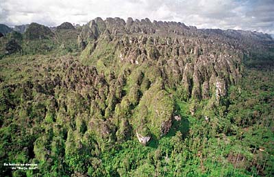
Study of the limestone formations of Mangkalihat - Borneo's vastest - which so far has never been properly investigated by a karstologist. These sharp-edged peaks and these pitons contain an incredible quantity of caves, mainly dry ones, free of water since a long time. In those the speleothems were formed as well as the clay deposits which trap useful information for archaeology: paleoclimatic or paleo-environmental data, etc.
That would make it possible to learn if there were more humid phases at the end of the last glaciation, (end of Pleistocene). This could explain for example why people left their rock-shelters, or why more marked erosion of the walls and therefore of paintings began.
Protection of the paintings
The thorough study of prehistoric paintings shows that, everywhere, the oldest ones were created on a fine layer of calcite which covers the limestone walls of the caves. This calcite probably had to settle several million years ago, when the water, that originally formed the tunnel, started to flow through lower levels. However, for some reasons not yet known, a specific bacterium attacks the layer of calcite and thus causes the destruction of paintings.
Without this erosion, one would probably find that caves like Gua Mardua or Gua Tewet were painted on their entire surface, since we found some remnants of ochre painting on every intact layer of calcite.
In Gua Tewet, we could observe paintings that cover some others. They are sometimes painted on a wall where the bed rock and bits of calcite layers alternate. This could prove the use of the caves during very distinct periods. The examination of the corrosion phenomena can give hints for dating the paintings. Lastly, such an analysis could form the basis for a protection policy of Borneo's caves paintings, by studying the various degrading agents: wind, rain, water circulation, bacteria, sunlight, forest fires.
Speleology
During our preceding explorations we had the chance to observe speleological phenomena of highest importance. But lack of time, equipment and manpower, prevented an adequate exploration. The potential for new discovery is immense. Gua Kambing offers a through-trip several kilometers long, which the swallows nests hunters use as shortcut, as it is less inconvenient than to cross the surface of the karst. According to our guides, there exists up to 7 fossil levels in this giant cavity. 600 meters lower, at the bottom of the karst, the resurgence of the underground water was found, indicating the unique depth potential for Borneo's karst.
The cave of Sedepan, with its gigantic entry that we reached in 1998 (and where the bird nests hunters told us they could collect up to 140 kg of nests every 40 days) is also the entrance of a surface river that according to the official map runs in the opposite direction. Using only aerial photographs and without access to local ground truth, the cartographers did not realize that the river flows underground through this giant sinkhole. In May 1999, we could see the resurgence of this river, some 5-km to the west. This river thus crosses an unexplored calcareous range by an underground course probably exceeding 30 kilometers.
All the speleological explorations will be documented by topography. The software TOPOROBOT will then be used to generate perspective views and virtual reality walk-throughs.
![]()
Planned
publications
The photographs of our 98' and 99' discoveries are, for the moment, distributed worldwide by the photo agency GAMMA. Publications in adventure and exploration magazines as well as in popular scientific or archaeological journals are considered.The whole of our discoveries will be published in the collection directed by Jean Clottes at Le Seuil edition (simultaneous translation in several languages) in 2002.
An interactive CD-ROM will also present our discoveries. It will be aimed at a young audience, to incite their interest in travel, adventure, and scientific endeavors. It should also provoke questions about the origin of mankind, and last but not least allow to virtually discover one of the last forgotten islands of the world.
Lastly, with the assistance of a camera team specialized in underground shots, we envisage to realize a one-hour documentary film for international broadcasting and some half-hour programs for a scientific and/or young audience.
![]()
© Le Kalimanthrope, 1999.